The consortium


![]()
Details for product :
| Upload date | 13 Mar 2017 |
| ECV | SEC |
| Product file | greenland_surface_elevation_change_cryosat2_v2_1.zip |
| File size | 26.6 MB |
Preview image :
Description :
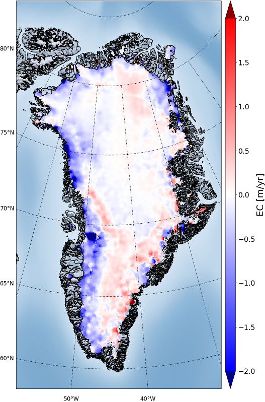
Greenland SEC grids from Cryosat-2. 2-yr and 5-yr means for 2011-2016
Comments :
The Cryosat2 Surface Elevation Change (SEC) version 2.1 product contains three different types of data files:
1) png plots of the surface elevation changes.
2) gridded ASCII files of the surface elevation changes and their associated errors
3) NetCDF files containing the surface elevation changes and their associated errors
Data are based on ESAs Baseline C product.
Given the longer time span of operation of the satellite, the data are now provided in 2-year means (2011-2012, 2012-2013, 2013-2014, 2014-2015, and 2015-2016) and five-year mean is also provided (2011-2015, 2012-2016).
The algorithms used to derive the product are explained in detail in (Simonsen and Sørensen, 2017). The approach used here corresponds to Least Squares Method (LSM) as described in the paper, in which the slope within each grid cell is accounted for by subtraction of the GIMP DEM; the data are corrected for both backscatter and leading edge width; and the LSM is solved at 1 km grid resolution (2 km search radius) and averaged in the post-processing to 5 km grid resolution and with a correlation length of 10/20 km.
Reference:
Simonsen, S. B. and Sørensen, L. S. (2017) ‘Implications of changing scattering properties on Greenland ice sheet volume change from Cryosat-2 altimetry’, Remote Sensing of Environment. Elsevier Inc., 190, pp. 207–216. doi: 10.1016/j.rse.2016.12.012.