The consortium


![]()
Details for product :
| Upload date | 09 Nov 2017 |
| ECV | SEC |
| Product file | greenland_surface_elevation_change_altika_v0_1.zip |
| File size | 5.7 MB |
Preview image :
Description :
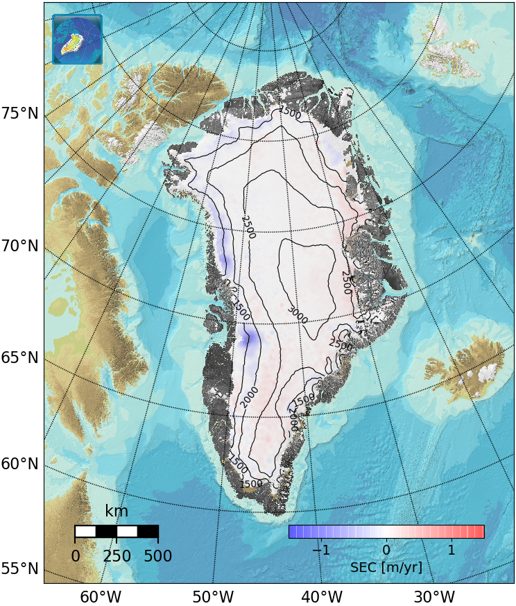
Experimental Greenland SEC grid from SARAL-AltiKa for 2013-2017 and corresp. grid from Cryosat-2
Comments :
Experimental SARAL-AltiKa Surface Elevation Change (SEC).
Version 0.1 of the product contains three files:
- NetCDF file containing the surface elevation change grids from AltiKa and from Cryosat-2 (for comparison) for 2013-2017 and their associated errors
- PNG plot of the surface elevation change from AltiKa
- PNG plot of the surface elevation change from Cryosat-2
As weather is directly imprinted in the accumulated snow on the Greenland ice sheet, the snow column is continually evolving. The Ku-band radar altimeter onboard Cryosat-2 enables for surface penetration of the upper snow (Simonsen & Sørensen 2017) and is highly susceptible for the presence of ice lenses (Nilsson et al. 2015).
This new experimental product of surface elevation change is based on data from the AltiKa-instrument onboard the France (CNES)/Indian (ISRO) SARAL satellite (Verron et al. 2015). The AktiKa altimeter utilizes Ka-band radar signals, which have less penetration in the upper snow. However, the surface slope and roughness has an imprint in the derived signal and the new product is only available for the flatter central parts of the Greenland ice sheet.
The corresponding SEC grid from Cryosat-2 is included for comparison. The algorithms used to derive this product are explained in detail in (Simonsen and Sørensen, 2017). The approach used here corresponds to Least Squares Method (LSM) 5 described in the paper, in which the slope within each grid cell is accounted for by subtraction of the GIMP DEM; the data are corrected for both backscatter and leading edge width; and the LSM is solved at 1 km grid resolution (2 km search radius) and averaged in the post-processing to 5 km grid resolution and with a correlation length of 20 km.
References:
Nilsson, J. et al., 2015. Greenland 2012 melt event effects on CryoSat-2 radar altimetry. Geophysical Research Letters, 42(10), pp.3919–3926.
Simonsen, S.B. & Sørensen, L.S., 2017. Implications of changing scattering properties on Greenland ice sheet volume change from Cryosat-2 altimetry. Remote Sensing of Environment, 190, pp.207–216.
Verron, J. et al., 2015. The SARAL / AltiKa Altimetry Satellite Mission. Marine Geodesy, 38, pp.2–21.