The consortium


![]()
Details for product :
| Upload date | 24 Sep 2020 |
| ECV | SEC |
| Product file | cci_sec_2020.tar.gz |
| File size | 84.6 MB |
Preview image :
Description :
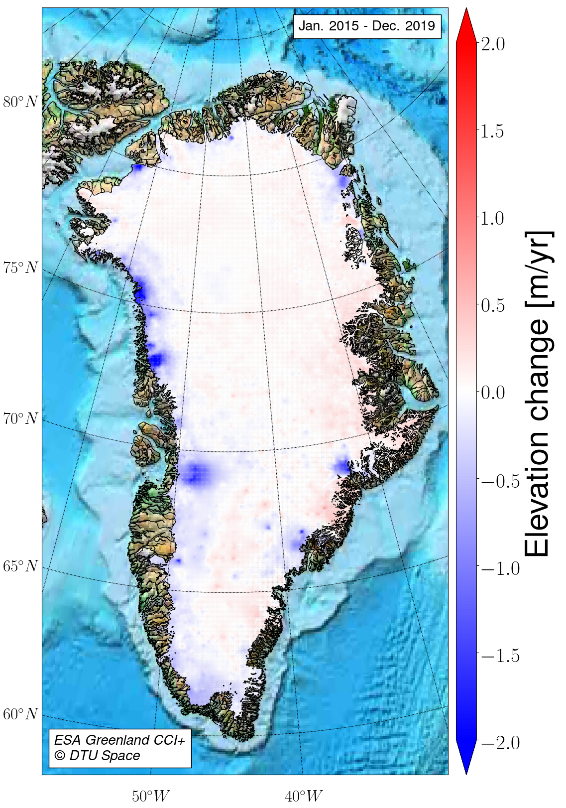
1992-2020 Greenland SEC from ERS-1, ERS-2, ENVISAT, Cryosat-2, and Sentinel-3 data, at 5-years means
Comments :
The Surface Elevation Change (SEC) version 2.0 product contains two different types of data files:
1) png plots of the surface elevation changes and error.
2) NetCDF files containing the surface elevation changes and their associated errors
Data are based on ESAs Ku-band radar satellite level-2 data products.
Given the longer time span of operation of the satellites, the data are provided at a five-year mean.
The algorithms used to derive the product are explained in detail in Simonsen and Sørensen (2017), and Sørensen et al. (2018). The approach used here is the most optimal combination of the XO-, TR-, and PF-algorithm; the data are corrected for both backscatter and leading-edge width, and solved at 1 km grid resolution and averaged in the post-processing to 5 km grid resolution by ordinary kriging.
Reference:
Simonsen, S. B., and Sørensen, L. S. (2017) ‘Implications of changing scattering properties on Greenland ice sheet volume change from Cryosat-2 altimetry’, Remote Sensing of Environment. Elsevier Inc., 190, pp. 207–216. DOI: 10.1016/j.rse.2016.12.012.
Sørensen, L. S., Simonsen, S. B., Forsberg, R., Khvorostovsky, K., Meister, R., and Engdahl, M. E. (2018) '25 years of elevation changes of the Greenland Ice Sheet from ERS, Envisat, and CryoSat-2 radar altimetry', Earth and Planetary Science Letters, 495, pp. 234-241 DOI: 10.1016/j.epsl.2018.05.015